
ENC Advisories
Active National Weather Service watches, warnings and advisories for the ENC Weather county coverage area, with the full details of each product.
Eastern North Carolina Watches / Warnings
Current alert polygons on the existing ENC-centered warning map.
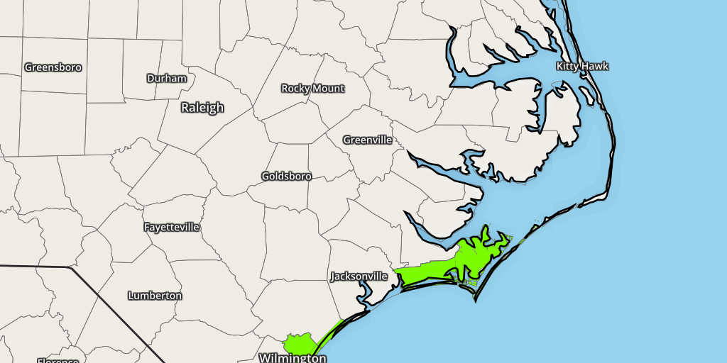
Current ENC Watches, Warnings & Advisories
Every active product affecting one or more counties in the ENC Weather coverage set is listed below with its timing, counties, full NWS description and instructions.
Beach Hazards Statement
Beach Hazards Statement issued October 23 at 3:58PM EDT until October 23 at 8:00PM EDT by NWS Newport/Morehead City NC
* WHAT...For the Coastal Flood Advisory, up to 1 to 2 feet of
inundation above ground level in low-lying areas near
shorelines and tidal waterways. For the Beach Hazards
Statement, dangerous rip currents and large breaking waves
expected in the surf zone.
* WHERE...Hatteras Island.
* WHEN...For the Coastal Flood Advisory, until 11 AM EDT Monday.
For the Beach Hazards Statement, until 8 PM EDT this evening.
* IMPACTS...Ocean overwash impacts will improve some this
morning as seas continue to subside. However, seas build some
tonight through the weekend which may bring additional minor
overwash in areas were dunes have been compromised. NC-12
between the Basnight Bridge and Rodanthe remains closed.
Today's high tide is around 6 pm this evening. Rip currents
can sweep even the best swimmers away from shore into deeper
water. Dangerous shore break can throw a swimmer or surfer
head first into the bottom causing neck and back injuries.
* ADDITIONAL DETAILS...Tide levels will continue to rise with King
Tide Cycle in place through the upcoming work-week. The morning
high tide will be the highest of the two daily tides. King Tide
peaks TUE and WED.
If travel is required, allow extra time as some roads may be
closed. Do not drive around barricades or through water of
unknown depth. Take the necessary actions to protect flood-prone
property.
Life-threatening rip currents. If caught in a rip current, remain
calm. Swim in a direction following the shoreline. If tired,
float or tread water until out of the rip current. If unable to
escape, face the shore and call or wave for help.
Shore break occurs when waves break directly on the beach. It is
extremely important to protect your head and neck whenever you
are in breaking waves by keeping your hands in front of you at
all times.
Beach Hazards Statement
Beach Hazards Statement issued October 23 at 3:58PM EDT until October 23 at 8:00PM EDT by NWS Newport/Morehead City NC
* WHAT...For the Beach Hazards Statement, dangerous rip currents
and large breaking waves in the surf zone. For the Coastal Flood
Advisory, up to 1 to 2 feet of inundation above ground level
expected in low- lying areas near shorelines and tidal
waterways.
* WHERE...Northern Outer Banks.
* WHEN...For the Beach Hazards Statement, until 8 PM EDT this
evening. For the Coastal Flood Advisory, from 5 AM Saturday to
11 AM EDT Monday.
* IMPACTS...Flooding of lots, parks, and roads with only
isolated road closures expected. Rip currents can sweep even
the best swimmers away from shore into deeper water. Dangerous
shore break can throw a swimmer or surfer head first into the
bottom causing neck and back injuries.
* ADDITIONAL DETAILS...Tide levels will continue to rise with King
Tide Cycle in place through the upcoming work-week. The morning
high tide will be the highest of the two daily tides. King Tide
peaks TUE and WED.
If travel is required, allow extra time as some roads may be
closed. Do not drive around barricades or through water of
unknown depth. Take the necessary actions to protect flood-prone
property.
Life-threatening rip currents. If caught in a rip current, remain
calm. Swim in a direction following the shoreline. If tired,
float or tread water until out of the rip current. If unable to
escape, face the shore and call or wave for help.
Shore break occurs when waves break directly on the beach. It is
extremely important to protect your head and neck whenever you
are in breaking waves by keeping your hands in front of you at
all times.
Coastal Flood Advisory
Coastal Flood Advisory issued October 23 at 3:58PM EDT until October 26 at 11:00AM EDT by NWS Newport/Morehead City NC
* WHAT...For the Coastal Flood Advisory, up to 1 to 2 feet of
inundation above ground level in low-lying areas near
shorelines and tidal waterways. For the Beach Hazards
Statement, dangerous rip currents and large breaking waves
expected in the surf zone.
* WHERE...Hatteras Island.
* WHEN...For the Coastal Flood Advisory, until 11 AM EDT Monday.
For the Beach Hazards Statement, until 8 PM EDT this evening.
* IMPACTS...Ocean overwash impacts will improve some this
morning as seas continue to subside. However, seas build some
tonight through the weekend which may bring additional minor
overwash in areas were dunes have been compromised. NC-12
between the Basnight Bridge and Rodanthe remains closed.
Today's high tide is around 6 pm this evening. Rip currents
can sweep even the best swimmers away from shore into deeper
water. Dangerous shore break can throw a swimmer or surfer
head first into the bottom causing neck and back injuries.
* ADDITIONAL DETAILS...Tide levels will continue to rise with King
Tide Cycle in place through the upcoming work-week. The morning
high tide will be the highest of the two daily tides. King Tide
peaks TUE and WED.
If travel is required, allow extra time as some roads may be
closed. Do not drive around barricades or through water of
unknown depth. Take the necessary actions to protect flood-prone
property.
Life-threatening rip currents. If caught in a rip current, remain
calm. Swim in a direction following the shoreline. If tired,
float or tread water until out of the rip current. If unable to
escape, face the shore and call or wave for help.
Shore break occurs when waves break directly on the beach. It is
extremely important to protect your head and neck whenever you
are in breaking waves by keeping your hands in front of you at
all times.
Coastal Flood Advisory
Coastal Flood Advisory issued October 23 at 1:15PM EDT until October 24 at 9:00AM EDT by NWS Wilmington NC
* WHAT...Up to one foot of inundation above ground level
expected in low-lying areas near shorelines and tidal
waterways.
* WHERE...Coastal Pender, Coastal New Hanover and Coastal
Brunswick Counties.
* WHEN...During the Friday evening and Saturday morning high tide
cycles.
* IMPACTS...Low-lying roads and locations along the Intracoastal
Waterway and adjacent tidal creeks may observe minor coastal
flooding. Check with local officials for any road closures or
impacts.
* ADDITIONAL DETAILS...Affected areas listed are based on
average tide conditions. Additional locations may experience
flooding during periods of heavy rainfall, high winds, or
other factors.
If travel is required, allow extra time as some roads may be
closed. Do not drive around barricades or through water of
unknown depth. Take the necessary actions to protect flood-prone
property.
Coastal Flood Advisory
Coastal Flood Advisory issued October 23 at 1:15PM EDT until October 24 at 11:00AM EDT by NWS Wilmington NC
* WHAT...Up to one foot of inundation above ground level
expected in low-lying areas near shorelines and tidal
waterways.
* WHERE...The lower Cape Fear River including downtown
Wilmington.
* WHEN...During the Friday evening and Saturday morning high tide
cycles.
* IMPACTS...Portions of Battleship Road and USS North Carolina
Road observe minor coastal flooding up to one foot in depth.
In downtown Wilmington, sections of Water Street observe minor
flooding up to one half foot in depth. Check with local
officials for any road closures or impacts.
* ADDITIONAL DETAILS...Affected areas listed are based on
average tide conditions. Additional locations may experience
flooding during periods of heavy rainfall, high winds, or
other factors.
If travel is required, allow extra time as some roads may be
closed. Do not drive around barricades or through water of
unknown depth. Take the necessary actions to protect flood-prone
property.
Coastal Flood Advisory
Coastal Flood Advisory issued October 23 at 3:58PM EDT until October 26 at 11:00AM EDT by NWS Newport/Morehead City NC
* WHAT...Up to 1 to 2 feet of inundation above ground level
expected in low-lying areas near shorelines and tidal waterways.
* WHERE...Areas along the Pamlico Sound, Trent, Bay and lower
Neuse Rivers, and adjacent tidal creeks.
* WHEN...From 5 AM Saturday to 11 AM EDT Monday.
* IMPACTS...Flooding of lots, parks, and roads with only
isolated road closures expected.
* ADDITIONAL DETAILS...Tide levels will continue to rise with King
Tide Cycle in place through the upcoming work-week. The morning
high tide will be the highest of the two daily tides. King Tide
peaks TUE and WED.
If travel is required, allow extra time as some roads may be
closed. Do not drive around barricades or through water of
unknown depth. Take the necessary actions to protect flood-prone
property.
Coastal Flood Advisory
Coastal Flood Advisory issued October 23 at 3:58PM EDT until October 26 at 11:00AM EDT by NWS Newport/Morehead City NC
* WHAT...For the Beach Hazards Statement, dangerous rip currents
and large breaking waves in the surf zone. For the Coastal Flood
Advisory, up to 1 to 2 feet of inundation above ground level
expected in low- lying areas near shorelines and tidal
waterways.
* WHERE...Northern Outer Banks.
* WHEN...For the Beach Hazards Statement, until 8 PM EDT this
evening. For the Coastal Flood Advisory, from 5 AM Saturday to
11 AM EDT Monday.
* IMPACTS...Flooding of lots, parks, and roads with only
isolated road closures expected. Rip currents can sweep even
the best swimmers away from shore into deeper water. Dangerous
shore break can throw a swimmer or surfer head first into the
bottom causing neck and back injuries.
* ADDITIONAL DETAILS...Tide levels will continue to rise with King
Tide Cycle in place through the upcoming work-week. The morning
high tide will be the highest of the two daily tides. King Tide
peaks TUE and WED.
If travel is required, allow extra time as some roads may be
closed. Do not drive around barricades or through water of
unknown depth. Take the necessary actions to protect flood-prone
property.
Life-threatening rip currents. If caught in a rip current, remain
calm. Swim in a direction following the shoreline. If tired,
float or tread water until out of the rip current. If unable to
escape, face the shore and call or wave for help.
Shore break occurs when waves break directly on the beach. It is
extremely important to protect your head and neck whenever you
are in breaking waves by keeping your hands in front of you at
all times.
Coastal Flood Advisory
Coastal Flood Advisory issued October 23 at 3:58PM EDT until October 26 at 11:00AM EDT by NWS Newport/Morehead City NC
* WHAT...Up to 1 to 2 feet of of inundation above ground level
expected in low-lying areas near shorelines and tidal waterways.
* WHERE...Areas along the beaches, Pamlico Sound, and adjacent
tidal creeks.
* WHEN...From 5 AM Saturday to 11 AM EDT Monday.
* IMPACTS...Flooding of lots, parks, and roads with only
isolated road closures expected.
* ADDITIONAL DETAILS...Tide levels will continue to rise with King
Tide Cycle in place through the upcoming work-week. The morning
high tide will be the highest of the two daily tides. King Tide
peaks TUE and WED.
If travel is required, allow extra time as some roads may be
closed. Do not drive around barricades or through water of
unknown depth. Take the necessary actions to protect flood-prone
property.
Coastal Flood Advisory
Coastal Flood Advisory issued October 23 at 3:58PM EDT until October 26 at 11:00AM EDT by NWS Newport/Morehead City NC
* WHAT...Up to 1 to 2 feet of inundation above ground level
expected in low-lying areas near shorelines and tidal waterways.
* WHERE...Areas in North Topsail Beach, along the lower New
River, White Oak River, Bogue and Core Sounds, and adjacent
tidal creeks.
* WHEN...From 5 AM Saturday to 11 AM EDT Monday.
* IMPACTS...Up to 1 to 2 feet of inundation above ground level is
possible in low-lying areas near shorelines and tidal waterways
resulting in a low threat of property damage. Some roads and
low lying property including parking lots, parks, lawns, and
homes adjacent to the waterfront will experience shallow
flooding.
* ADDITIONAL DETAILS...Tide levels will continue to rise with King
Tide Cycle in place through the upcoming work-week. The morning
high tide will be the highest of the two daily tides. King Tide
peaks TUE and WED.
If travel is required, allow extra time as some roads may be
closed. Do not drive around barricades or through water of
unknown depth. Take the necessary actions to protect flood-prone
property.
ENC County-by-County Status
All counties monitored by this page are shown here, including counties with no current advisory.
Related ENC Weather Pages
More detail for warnings, radar and severe-weather analysis.
ENC watches, warnings and warning-map tools.
Open →RadarInteractive National RadarInteractive radar for current precipitation and storms.
Open →SPCSevere WeatherConvective outlook and severe-weather resources.
Open →MapsWeather MapsRadar, satellite, temperatures and alerts.
Open →