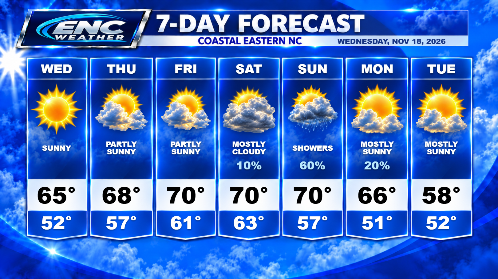
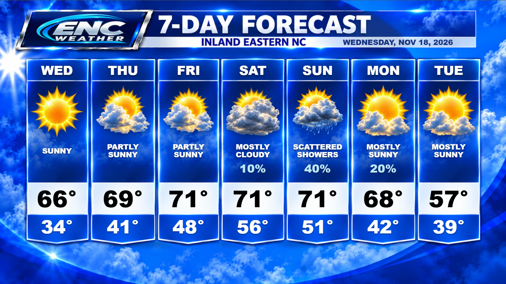
One more chilly start to our morning as temperatures hover around freezing inland at sunrise. Temperatures will start to increase this week (even overnight temperatures) as surface high pressure and upper-level ridging control the remaining week’s weather. Highs should start to climb to the low 70s be the end of the week with overnight lows rising as well.
What was once a quiet weather pattern is starting to look like its coming to an end. An upper-level disturbance will be impacting Florida from mid-week through the end of the week. This will lead to a surface low developing off the coast of Florida by the end of the week which will begin to track northward over the weekend. Some uncertainly exists surrounding this low which I will discuss.
Forecast models have started to be more consistent with the initial development of this low. This is increasing the confidence that some sort of system will develop off the Florida coast. At this time, there are a couple of different potential impacts that this could have on ENC. What type of impact this will have will depend on strength and speed of the low once it develops.
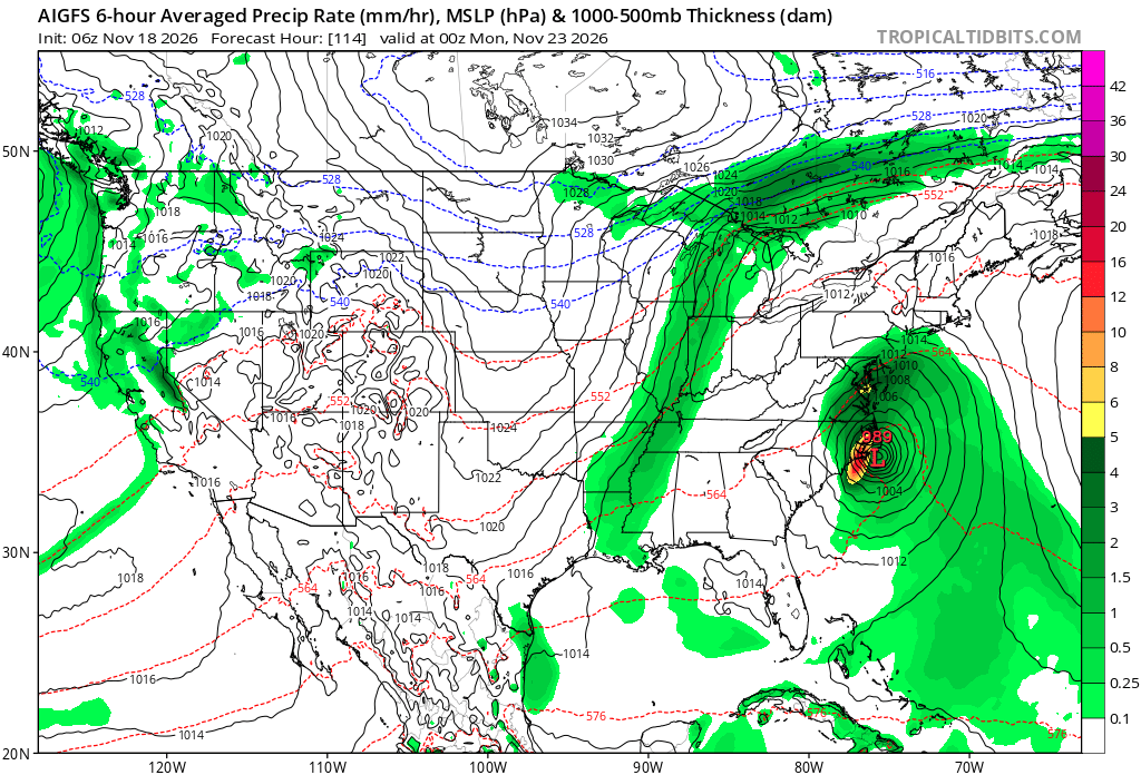
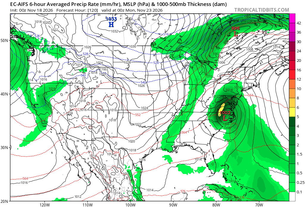
As we go through our Saturday, the low (should already be developed at this point) should begin its northward track just off the southeast coast. It will be picked up by an upper-level trough crossing the CONUS this weekend which will help turn it more northeast as it approaches. This turn to the northeast and where it happens is important to the eventual track and therefore, impacts to ENC. A faster forward speed initially allows the low to track further inland (before being turned northeast) leading to potentially more thunderstorm possibilities and heavy rainfall rates. A slower forward speed will allow the trough to turn the low northeast before the low has a chance to make significant inland ground and potentially keeping it closer to the coast or just offshore reducing the inland rainfall amounts and also reducing the chance of thunderstorms across most of the area.
The spread from the models on track does reduce confidence in this weekend’s forecast as the center of the low can be as far west as central NC (mostly inland impacts) or off the Outer Banks (mostly coastal impacts). Unfortunately, determining which solution at this stage is closer to verifying is difficult. If I had to give a guess based on my experience with storms like this, I think a track that bring the center of the low just over the Sounds (just west of the Outer Banks but east of the inland areas) seems to be the most likely outcome. My thinking is probably closer to the AIGFS than anything.
There has been some talk about whether this will become tropical or not. The models do indicate that there is potential that this could potentially obtain tropical/subtropical status but I caution jumping on that bandwagon too early based on model data at this time of year. The NHC hasn’t issued any type of forecast or mentioned the potential for development in their outlooks at the time of this writing. If what the models are indicating (especially the AIGFS) actually occurs, then that discussion will be needed. It’s important to note that whether this does get classified as tropical or not, the impacts to the east coast will not change. We could potentially see a very strong low track up the east coast with the potential for heavy rain, wind, and beach erosion. Whether it does it as Kyle, a nor’easter, or a coastal low doesn’t matter.
Once we get past this event, our attention will then turn to the potentially more active subtropical jet that typically fires up in El Nino years.
Update: Since this post, the NHC has issued a 40% chance of development over the next 7 days for the low pressure system forecast to develop off the Florida coast. Model runs since this morning’s update have not resolved the complex set up with many variables contributing to the uncertainty; speed, timing of the trough, potential for interaction with a second low over the Atlantic. My previous thinking still stands as of early afternoon but may need to be adjusted if the facts change over the next several days.